
Experts + AI for
GEOTHERMAL
EnviTrace provides you with experts and AI software for geothermal projects.
GeoTGo
- Software-as-a-Service (SaaS) subscriptions (monthly/annual) will allow users to:
- Define a geographic region to analyze for geothermal potential (currently, supports only U.S.)
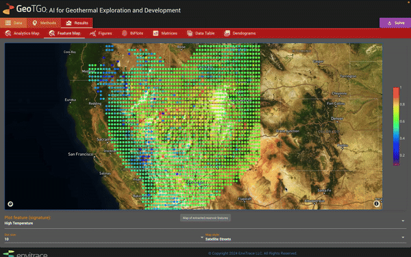
- Obtain interactive maps showing features essential for specific geothermal projects.
- Evaluate alternative energy extraction methods and their potential impacts on the environment.
- Explore interactive plots of data and feature relationships.
- Support in the form of consulting, tutorials, and documentation.
GeoTGo+
- All features of the regular GeoTGo plan, plus:
- Dedicated access to our team of geothermal and AI experts.
- Hands-on guidance related to software utilization.
- Ability to process and analyze your own proprietary data.
- We will work hand in hand with your team for the duration of your project, tailoring our services to your goals.
- Reduced compute costs for the duration of your project.
- Third-party software integration and APIs.
Why AI?
FOR GEOTHERMAL
Traditional geothermal exploration methods rely on direct ground surface and subsurface observations. The problem is that making these measurements can be costly, existing data are sparse, and many hotspots are hidden not displaying obvious physical or geochemical signs.
Our AI that can identify these hidden geothermal hotspots. By training on large sets of available geological data, GeoTGo has learned which physical characteristics coincide with high geothermal potential, so it can find high value targets in your area using already existing data.


SUCCESS IS IN THE
Details
Finding a high potential geothermal location is only the first step. GeoTGo can play a crucial role in all phases of a geothermal project.
- Site Assessment
- GeoTGo can characterize geothermal reservoir properties and conditions.
- Environmental Impact
- GeoTGo can predict and help mitigate the potential negative impacts of geothermal development on the environment, including groundwater flow changes, contaminant leaks, induced seismicity, and land subsidence.
- Drilling and Well Construction
- GeoTGo supports optimization of exploration and production, including well configurations and design.
AVAILABLE
Everywhere
GeoTGo is cloud-based AI software that is available online, making it instantly and easily accessible to your team. It allows users to define a location, select computational settings, and upload their own proprietary datasets. GeoTGo outputs include maps, charts, plots presenting extracted information, performed decision analyses, and evaluated return of investment (RoI).

Features
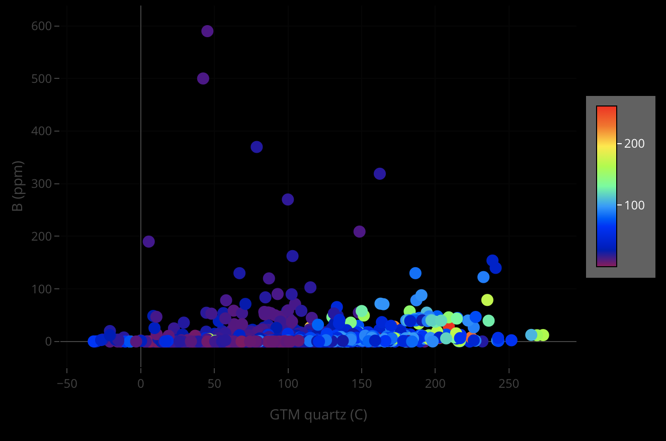
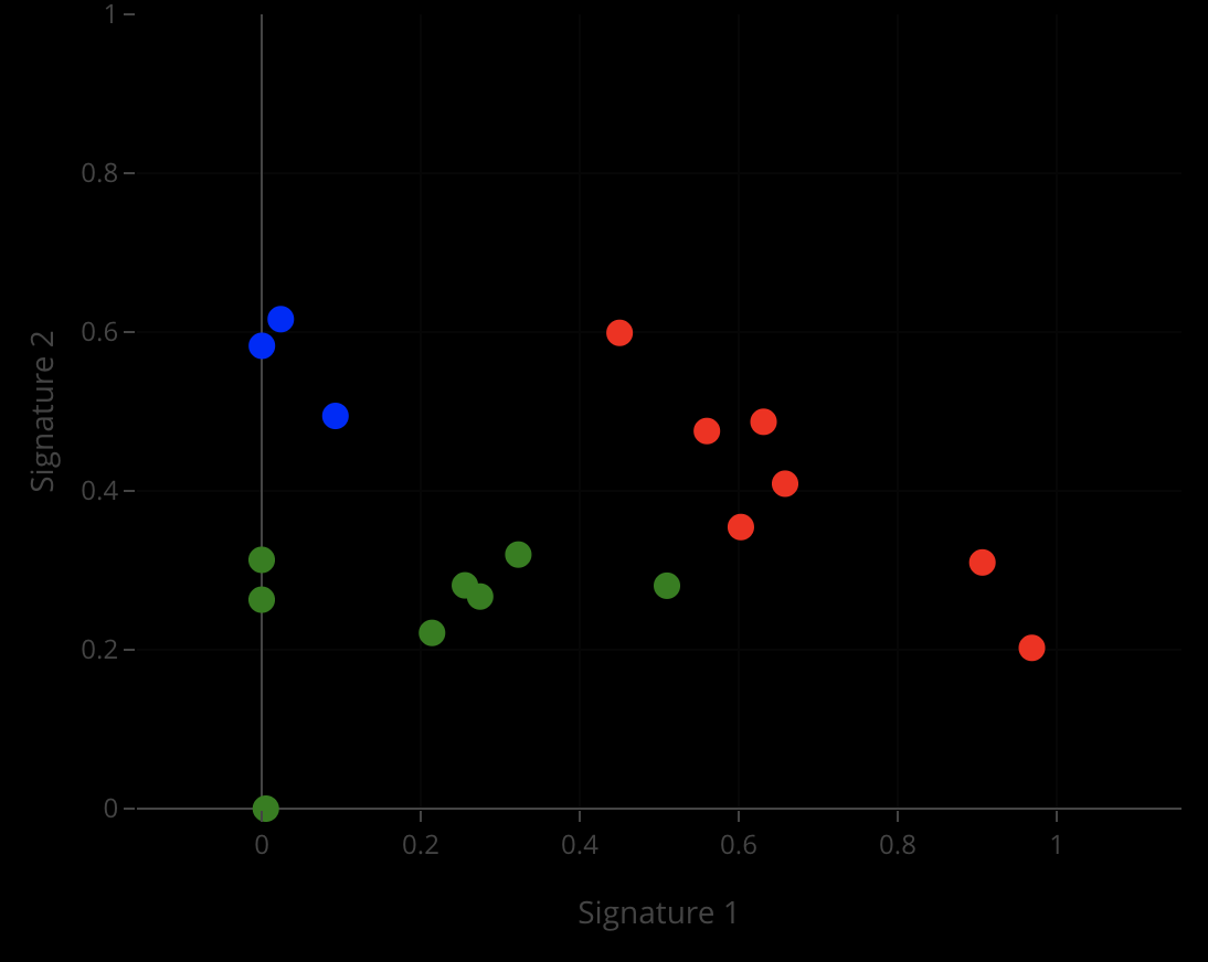
Data Plots
Presenting data relationships.
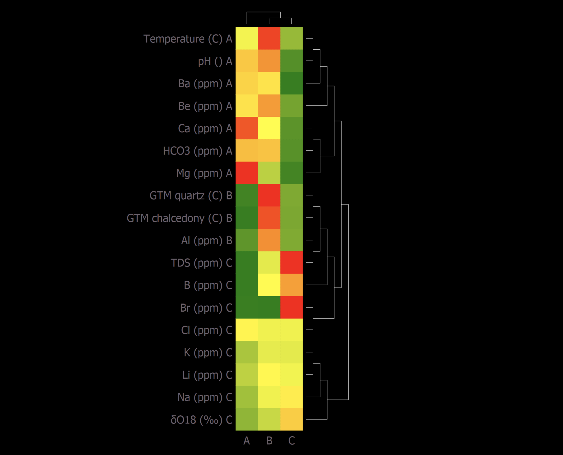
Dendrograms
Representing extracted hidden features.
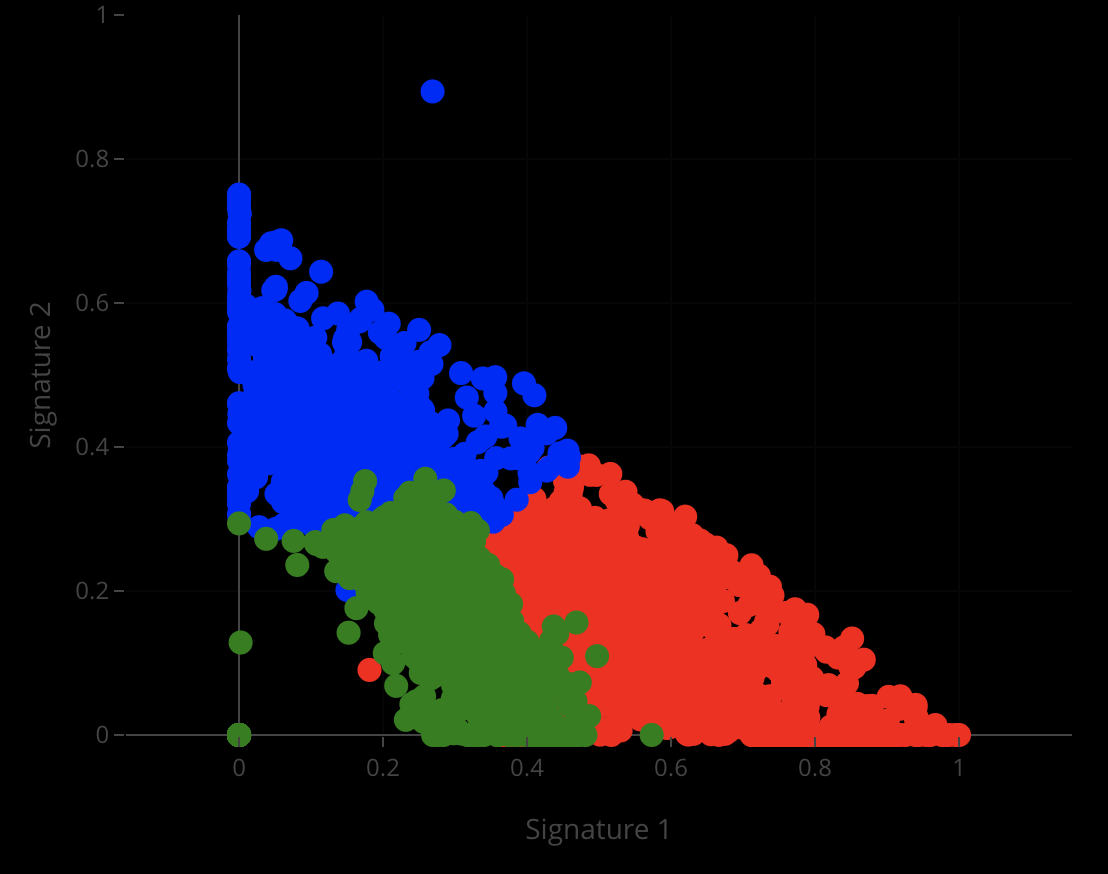
Location Bi-Plots
Relating features to locations.
Attribute Bi-Plots
Relating features to attributes.
New Resource Hub
Explore the GeoTGo Informational Database
Access installation guides, training tracks, New Mexico regulations, tax incentives, reports, and media that support geothermal utilization projects.
Related publications
- Machine Learning Estimates of Geothermal and Critical Mineral Prospectivity of the Great Basin (2026) — V.V. Vesselinov, T.L. Kliphuis — Stanford Geothermal Workshop
- AI-augmented geothermal model for scalable energy uncertainties in buildings (2026) — A. Markowitz et al. — Scientific Reports
- Deep-Embedded-Clustering of Microseismicity Identifies Multiple Failure Mechanisms at The Geysers Geothermal Field (2026) — P. Lara et al. — Geophysics (submitted)
- GeoDAWN To GeoTGo: From Complex Data To Decisions Related To Geothermal Prospectivity (2025) — T.L. Kliphuis et al. — Stanford Geothermal Workshop, Stanford, CA
- Machine-Learning Methods and Tools Designed for Community-Based Equitable and Inclusive Geothermal Development (2024) — V.V. Vesselinov, H. Jasperson, T.L. Kliphuis — Stanford Geothermal Workshop, Stanford, CA
- Machine Learning for Geothermal Resource Exploration in Tularosa Basin, New Mexico (2023) — M. Mudunuru et al. — Energies
- A Progress Report on GeoThermalCloud: Framework An Open-Source Machine Learning Based Tool for Discovery, Exploration, and Development of Hidden Geothermal Resources (2022) — B. Ahmmed et al. — Stanford Geothermal Workshop, Stanford, CA
- Discovering hidden geothermal signatures using non-negative matrix factorization with customized k-means clustering (2022) — V.V. Vesselinov et al. — Geothermics
- GeoThermalCloud: Machine Learning for Discovery, Exploration, and Development of Hidden Geothermal Resources (2022) — V.V. Vesselinov et al. — Stanford Geothermal Workshop, Stanford, CA
- GeoThermalCloud: Machine learning for geothermal resource exploration (2022) — M. Mudunuru, V.V. Vesselinov, B. Ahmmed — Journal of Machine Learning for Modeling and Computing
- Machine learning and a process model to better characterize hidden geothermal resources (2022) — M. Ahmmed, V.V. Vesselinov — Geothermal Rising Conference (transactions)
- Machine learning and shallow groundwater chemistry to identify geothermal prospects in the Great Basin (2022) — B. Ahmmed, V.V. Vesselinov — Renewable Energy
- Machine Learning to Discover, Characterize, and Produce Geothermal Energy (2022) — V.V. Vesselinov et al. — Machine Learning Applications in Subsurface Energy Resource Management
- Discovering the Hidden Geothermal Signatures of Southwest New Mexico (2021) — V.V. Vesselinov et al. — World Geothermal Congress, Reykjavik, Iceland
- Machine learning to identify geologic factors associated with production in geothermal fields: A case-study using 3D geologic data, Brady geothermal field, Nevada (2021) — D.L. Siler, J.D. Pepin, V.V. Vesselinov, et al. — Geothermal Energy
- Discovering Signatures of Hidden Geothermal Resources based on Unsupervised Learning (2020) — V.V. Vesselinov et al. — Stanford Geothermal Workshop
Related presentations
- Science-informed machine learning for reservoir characterization (2026) — V.V. Vesselinov, T.L. Kliphuis — Computational Methods in Water Resources (CMWR), Bologna, Italy
- BEYOND PROSPECTIVITY MAPS: Multimodal Geospatial AI for Critical Mineral Systems and Geothermal Prospectivity Exploration (2026) — V.V. Vesselinov, T.L. Kliphuis — ML4SEG (Machine Learning for Solid Earth Geosciences and Earthquake Physics), Sicily, Italy
- Imaging Subsurface Reservoirs for Hydrogen, Geothermal, and Critical Minerals: Multi-Physics Imaging and AI-Assisted Interpretation (2026) — V.V. Vesselinov, T.L. Kliphuis — AI for Geological Mapping and Modelling Conference (AIGMM), Utrecht, Netherlands
- Machine Learning Estimates of Geothermal and Critical Mineral Prospectivity of the Great Basin (2026) — V.V. Vesselinov, T.L. Kliphuis — Stanford Geothermal Workshop
- Machine Learning Estimates of Geothermal and Critical Mineral Prospectivity of the Great Basin (2026) — V.V. Vesselinov, T. Kliphuis — Stanford Geothermal Workshop
- GeoDAWN & GeoFLIGHT to GeoTGo: From complex data to defensible decisions related to geothermal prospectivity (2025) — V.V. Vesselinov et al. — Stanford Geothermal Workshop
- Mapping geothermal resources using AI/ML (2024) — T. Kliphuis, H. Jasperson, V.V. Vesselinov — New Mexico Geological Society Annual Spring Meeting
- GeoTGO: Equitable and Inclusive Tool for Community-Based Geothermal (2023) — T. Kliphuis, M. Bluehouse, V.V. Vesselinov — Stanford Geothermal Workshop
- Machine learning and a process model to better characterize hidden geothermal resources (2022) — M. Ahmmed, V.V. Vesselinov — Geothermal Rising Conference (GRC)
- Novel machine learning methods and tools for geothermal and geochemical problems (2022) — V.V. Vesselinov, T. Kliphuis — AGU Fall Meeting
- Physics-Informed Machine Learning of Geothermal, Geomechanical, Geochemical Process (2022) — V.V. Vesselinov, T. Kliphuis — AGU Fall Meeting
- GeoThermalCloud: Cloud Fusion of Big Data and Multi-Physics Models using Machine Learning for Discovery, Exploration and Development of Hidden Geothermal Resources (2021) — V.V. Vesselinov, et al. — Department of Energy, Geothermal Office
- GeoThermalCloud: Fusion of Big Data and Multi-Physics Models (2021) — V.V. Vesselinov, et al. — JuliaCon, Boston, MA
- Hidden geothermal signatures of the southwest New Mexico (2021) — V.V. Vesselinov, et al. — World Geothermal Congress, Reykjavik, Iceland
- Machine Learning to Characterize the State of Stress and its Influence on Geothermal Production (2021) — V.V. Vesselinov, et al. — Geothermal Rising Conference
- Discovering Hidden Geothermal Signatures using Unsupervised Machine Learning (2020) — V.V. Vesselinov, et al. — Stanford Geothermal Workshop
- Machine learning for geothermal resource analysis and exploration (2020) — V.V. Vesselinov, et al. — XXIII International Conference on Computational Methods in Water Resources (CMWR), Stanford, CA
- Site-Scale and Regional-Scale Modeling for Geothermal Resource Analysis and Exploration (2020) — M. Mudunuru, V.V. Vesselinov, et al. — Geothermal Workshop, Stanford, CA